Alertes en vigueur Afton, WI
If outdoors, consider seeking shelter inside a building.
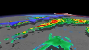
At 731 PM CDT, Doppler radar was tracking strong thunderstorms alonga line extending from near Footville to near Monroe. Movement waseast at 30 mph.HAZARD...Wind gusts up to 40 mph and half inch hail.SOURCE...Radar indicated.IMPACT...Gusty winds could knock down tree limbs and blow aroundunsecured objects. Minor hail damage to vegetation ispossible.Locations impacted include...Janesville, Beloit, Monroe, Brodhead, Clinton, Sharon, Orfordville,Albany, Footville, Newark, Magnolia, Tiffany, Hanover, Avalon, Afton,Shopiere, Avon, Juda, Leyden, and Foxhollow.This includes the following highways...Interstate 39/90 between mile markers 172 and 186.Interstate 43 between mile markers 0 and 11.
For your protection move to an interior room on the lowest floor of abuilding.
At 757 PM CDT, a severe thunderstorm was located near Darien, or 7miles west of Delavan, moving east at 40 mph.HAZARD...60 mph wind gusts and quarter size hail.SOURCE...Trained weather spotters.IMPACT...Hail damage to vehicles is expected. Expect wind damage toroofs, siding, and trees.Locations impacted include...Janesville, Elkhorn, Delavan, Lake Geneva, Milton, Williams Bay,Genoa City, Walworth, Clinton, Fontana-On-Geneva Lake, Sharon,Darien, Como, Pell Lake, Powers Lake, Richmond, Springfield, Tiffany,Avalon, and Delavan Lake.